
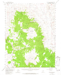
1958 Map of Pine Grove Hills
USGS Topo · Published 1960About this map
Pine Grove and Rockland anchor this high-altitude landscape of the Pine Grove Hills, where mining interests dominated the mid-century terrain. The presence of numerous prospects, shafts, and tunnels reflects an active period of resource extraction, centered around major operations like the Wilson Mines, Wheeler Mine, and Rockland Mines. These sites are concentrated in rugged canyons like Pine Grove Canyon and along the slopes of Mt Etna.
Find a feature on this map
58 named features on this map. Tap any name to fly to it.
Don’t see what you’re looking for? This feature index may not catch every label — zoom into the map to look around manually.
Map Details
Editions of this 1958 Pine Grove Hills Map
2 editions found
Other maps of this area

1891 · Wellington
USGS Topo · 1:125,000

1893 · Wellington
USGS Topo · 1:125,000

1909 · Hawthorne
USGS Topo · 1:250,000

1909 · Bridgeport
USGS Topo · 1:125,000

1911 · Bridgeport
USGS Topo · 1:125,000

1911 · Hawthorne
USGS Topo · 1:250,000

1915 · Hawthorne
USGS Topo · 1:250,000

1920 · Bridgeport
USGS Topo · 1:125,000

1948 · Walker Lake
USGS Topo · 1:250,000

1956 · Mt. Grant
USGS Topo · 1:62,500