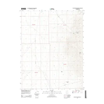
2014 Map of Pine Grove Reservoir
USGS Topo · Published 2014About this map
Pine Grove sits at the high-elevation transition where the alluvial flats of the Pine Valley Wash meet the steep western face of the Wah Wah Mountains. This 2014 survey documents a landscape defined by seasonal water management, with the Pine Grove Reservoir and Woods Reservoir capturing runoff from the rugged drainages of Moonshine Canyon and Rose Spring Canyon. The drainage pattern reflects the arid character of Beaver County, where intermittent flows like Indian Cr and Commissary Cr descend from the heights into the broad valleys below. Navigational infrastructure is limited to primitive routes such as Pine Grove Rd and Pine Valley Rd, which trace the base of the mountains to connect the remote settlement of Pine Grove with the surrounding range. The map provides a detailed view of the township and range system, including t28s r16w and t29s r17w, essential for locating specific land parcels in this high-desert terrain.
Find a feature on this map
19 named features on this map. Tap any name to fly to it.
Don’t see what you’re looking for? This feature index may not catch every label — zoom into the map to look around manually.
Map Details
Editions of this 2014 Pine Grove Reservoir Map
This is the sole edition of this map. No revisions or reprints were ever made.
Other maps of this area

1953 · Richfield
USGS Topo · 1:250,000

1958 · Richfield
USGS Topo · 1:250,000

1971 · Observation Knoll
USGS Topo · 1:24,000

1971 · Pine Grove Reservoir
USGS Topo · 1:24,000

1971 · Pinto Spring
USGS Topo · 1:24,000

1971 · Sewing Machine Pass
USGS Topo · 1:24,000

1971 · Sawtooth Peak
USGS Topo · 1:24,000

1971 · Lamerdorf Peak NW
USGS Topo · 1:24,000
1971 · The Tetons
USGS Topo · 1:24,000

1971 · Lamerdorf Peak
USGS Topo · 1:24,000