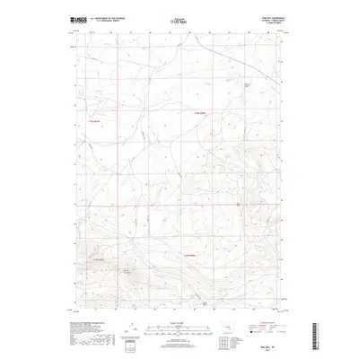
2017 Map of Pine Hill
USGS Topo · Published 2017About this map
The Shirley Mountains anchor the southern portion of this high-altitude Carbon County landscape, where the terrain drops away into the Little Basin. This 2017 survey reveals an intricate network of drainage systems feeding into Muddy Cr, which carves through the northern half of the quadrangle near the distinctive Point of Rocks formation. The naming conventions of the region reflect the challenges of early travel and ranching, evidenced by features such as Difficulty Cr, Difficulty Rd, and Difficulty Spring. A sparse but essential infrastructure of rural routes, including Blm Rd 3115 and Co RD 102, provides the only access across these high-country slopes. Named peaks and ridges like Pine Hill stand as navigational waypoints in a territory defined by seasonal water sources such as Little Rock Spring Cr and Hay Slough.
Find a feature on this map
22 named features on this map. Tap any name to fly to it.
Don’t see what you’re looking for? This feature index may not catch every label — zoom into the map to look around manually.
Map Details
Editions of this 2017 Pine Hill Map
This is the sole edition of this map. No revisions or reprints were ever made.
Other maps of this area

1953 · Fourmile Point
USGS Topo · 1:24,000

1953 · The Q Ranch
USGS Topo · 1:24,000

1953 · T E Ranch
USGS Topo · 1:24,000

1955 · Casper
USGS Topo · 1:250,000

1958 · Casper
USGS Topo · 1:250,000

1960 · Wild Irish Reservoir
USGS Topo · 1:24,000

1960 · Measel Spring Reservoir
USGS Topo · 1:24,000
1961 · Pine Hill
USGS Topo · 1:24,000
1961 · Windy Hill
USGS Topo · 1:24,000
1961 · Difficulty
USGS Topo · 1:24,000