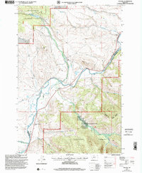
1997 Map of Pine Hill
USGS Topo · Published 2002About this map
Christianson Ranch and the Wallace Christianson Ranch anchor this high-country landscape along the Big Hole River as it was mapped in the late 1990s. The region is defined by a network of family-named agricultural holdings, including Bacon Ranch, Nichols Ranch, and Smith Ranch, which reflect the long-standing ranching traditions of Beaverhead National Forest.
Find a feature on this map
25 named features on this map. Tap any name to fly to it.
Don’t see what you’re looking for? This feature index may not catch every label — zoom into the map to look around manually.
Map Details
Editions of this 1997 Pine Hill Map
This is the sole edition of this map. No revisions or reprints were ever made.
Other maps of this area

1955 · Dillon
USGS Topo · 1:250,000

1957 · Dillon
USGS Topo · 1:250,000

1958 · Dillon
USGS Topo · 1:250,000

1962 · Dillon
USGS Topo · 1:250,000

1962 · Lower Seymour Lake
USGS Topo · 1:24,000

1962 · Mud Lake
USGS Topo · 1:24,000

1962 · Pine Hill
USGS Topo · 1:24,000
1962 · Foolhen Mountain
USGS Topo · 1:24,000

1962 · Pintlar Lake
USGS Topo · 1:24,000

1962 · Proposal Rock
USGS Topo · 1:24,000