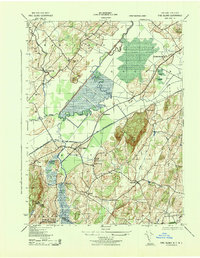
1943 Map of Pine Island
USGS Topo · Published 1943About this map
The Wallkill River and the engineered Cheechunk Canal dominate this landscape during the mid-war era, illustrating a complex system of drainage and transit in the fertile black dirt region. Agricultural and industrial interests intersect at Pine Island, where the Erie (Pine Island Branch) rail line terminates near the St Stanislaus Ch. The presence of the Universal Atlas Cement Co near Eden highlights the local extraction and processing economy that flourished alongside traditional farming.
Find a feature on this map
33 named features on this map. Tap any name to fly to it.
Don’t see what you’re looking for? This feature index may not catch every label — zoom into the map to look around manually.
Map Details
Editions of this 1943 Pine Island Map
This is the sole edition of this map. No revisions or reprints were ever made.
Other maps of this area

1888 · Franklin
USGS Topo · 1:62,500

1891 · Greenwood Lake
USGS Topo · 1:62,500

1893 · Greenwood Lake
USGS Topo · 1:62,500

1894 · Franklin
USGS Topo · 1:62,500

1897 · Franklin
USGS Topo · 1:62,500

1903 · Franklin Furnace
USGS Topo · 1:62,500

1903 · Greenwood Lake
USGS Topo · 1:62,500

1906 · Port Jervis
USGS Topo · 1:62,500

1906 · Goshen
USGS Topo · 1:62,500

1908 · Goshen
USGS Topo · 1:62,500