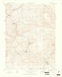
1945 Map of Pine
USGS Topo · Published 1962About this map
North Fork South Platte River winds through the heart of this mid-century survey, defining a landscape where narrow gulches and mountain ranching converge. The settlement of Pine serves as a central hub, situated near the confluence where Elk Creek meets the river. The presence of several named family operations, such as Clise Ranch, Green Ranch, and Z Bar D Ranch, reflects a ranching economy established in the high terrain of the Pike National Forest.
Find a feature on this map
38 named features on this map. Tap any name to fly to it.
Don’t see what you’re looking for? This feature index may not catch every label — zoom into the map to look around manually.
Map Details
Editions of this 1945 Pine Map
4 editions found
Other maps of this area

1893 · Platte Canyon
USGS Topo · 1:125,000

1899 · West Denver
USGS Topo · 1:125,000

1945 · Indian Hills
USGS Topo · 1:31,680

1945 · Platte Canyon
USGS Topo · 1:24,000

1945 · Pine
USGS Topo · 1:24,000

1945 · Bailey
USGS Topo · 1:24,000

1948 · Pine
USGS Topo · 1:24,000

1948 · Platte Canyon
USGS Topo · 1:24,000

1949 · Bailey
USGS Topo · 1:24,000

1953 · Denver
USGS Topo · 1:250,000