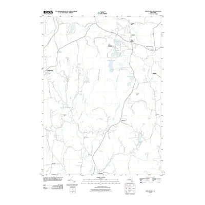
2010 Map of Pine Plains
USGS Topo · Published 2010About this map
Stissing Mountain and Little Stissing Mountain anchor the central landscape of this Dutchess County region, creating a natural divide between the water systems of Wappinger Creek and Shekomeko Creek. The settlement pattern follows these lowlands, with the village of Pine Plains serving as a primary hub near Evergreen Cemetery and the northern waters of Stissing Pond. The area is characterized by a high density of named family and local landmarks, from Pachin Mills and Hammertown in the north to the southern hamlets of Bangall and McIntyre. Genealogists may find value in the specific road network names like Strever Farm Rd and Conklin Hill Rd, which reflect the long-standing agricultural heritage of the valley. Significant water bodies including Hunns Lake, Thompson Pond, and Halcyon Lake are preserved here alongside the path of the Taconic State Pkwy along the western edge.
Find a feature on this map
79 named features on this map. Tap any name to fly to it.
Don’t see what you’re looking for? This feature index may not catch every label — zoom into the map to look around manually.
Map Details
Editions of this 2010 Pine Plains Map
This is the sole edition of this map. No revisions or reprints were ever made.
Other maps of this area

1895 · Catskill
USGS Topo · 1:62,500

1898 · Rhinebeck
USGS Topo · 1:62,500

1899 · Millbrook
USGS Topo · 1:62,500

1902 · Millbrook
USGS Topo · 1:62,500

1902 · Copake
USGS Topo · 1:62,500

1904 · Copake
USGS Topo · 1:62,500

1934 · Rhinebeck
USGS Topo · 1:48,000

1934 · Catskill
USGS Topo · 1:62,500

1938 · Catskill
USGS Topo · 1:62,500

1939 · Rhinebeck
USGS Topo · 1:62,500