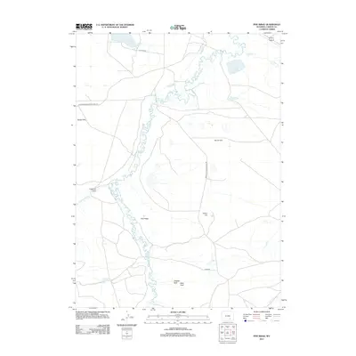
2012 Map of Pine Ridge
USGS Topo · Published 2012About this map
The Medicine Bow River meanders sharply through this high-plains landscape in Carbon County, defining the drainage patterns and supporting a network of irrigation works like the Vandiver Ditch and Thornton Ditch. The terrain is characterized by broad, named expanses such as Spade Flats and Horne Flats, which are punctuated by distinct geological landmarks like Alligator Rock and Bible Rock near the southern boundary. This 2012 survey reveals the sparse but intentional infrastructure of the region, where gravel roads like Co Rd 320 and Elk Mountain Medicine Bow Rd navigate around significant water bodies such as East Allen Lake and Horne Lake. The eponymous Pine Ridge and nearby Indian Hill provide the primary vertical relief in an area primarily shaped by the river's winding course and the historical management of water for ranching or agricultural use.
Find a feature on this map
19 named features on this map. Tap any name to fly to it.
Don’t see what you’re looking for? This feature index may not catch every label — zoom into the map to look around manually.
Map Details
Editions of this 2012 Pine Ridge Map
This is the sole edition of this map. No revisions or reprints were ever made.
Other maps of this area

1914 · Saddleback Hills
USGS Topo · 1:62,500

1915 · Como Ridge
USGS Topo · 1:48,000

1918 · Como Ridge
USGS Topo · 1:62,500

1921 · Saddleback Hills
USGS Topo · 1:62,500

1954 · Rawlins
USGS Topo · 1:250,000

1958 · Rawlins
USGS Topo · 1:250,000

1958 · Mc Fadden
USGS Topo · 1:24,000
1958 · Pierce Reservoir
USGS Topo · 1:24,000

1958 · T L Ranch
USGS Topo · 1:24,000

1962 · Rawlins
USGS Topo · 1:250,000