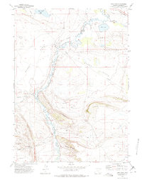
1971 Map of Pine Ridge
USGS Topo · Published 1975About this map
The Medicine Bow River meanders across this Wyoming landscape, defining a terrain of high plains and geological outcrops in the early 1970s. The northern edge of the sheet is anchored by the Union Pacific railroad corridor, while the central and western reaches are dominated by the broad expanses of Spade Flats and Horne Flats. Rising above the river valley, the prominent escarpment of Pine Ridge provides a distinct vertical contrast to the surrounding basins, leading toward landmarks like Indian Hill and the uniquely named Alligator Rock.
Find a feature on this map
22 named features on this map. Tap any name to fly to it.
Don’t see what you’re looking for? This feature index may not catch every label — zoom into the map to look around manually.
Map Details
Editions of this 1971 Pine Ridge Map
This is the sole edition of this map. No revisions or reprints were ever made.
Other maps of this area

1914 · Saddleback Hills
USGS Topo · 1:62,500

1915 · Como Ridge
USGS Topo · 1:48,000

1918 · Como Ridge
USGS Topo · 1:62,500

1921 · Saddleback Hills
USGS Topo · 1:62,500

1954 · Rawlins
USGS Topo · 1:250,000

1958 · Rawlins
USGS Topo · 1:250,000

1958 · Mc Fadden
USGS Topo · 1:24,000
1958 · Pierce Reservoir
USGS Topo · 1:24,000

1958 · T L Ranch
USGS Topo · 1:24,000

1962 · Rawlins
USGS Topo · 1:250,000