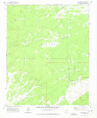
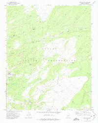
1971 Map of Pine Springs
USGS Topo · Published 1975About this map
The Navajo Indian Reservation within the high desert landscape of Apache County is defined here by its scattered water infrastructure and remote transportation network. Centered on the small settlement of Pine Springs, this 1971 record reveals a community dependent on a series of critical water sources, including the Pine Springs Well, Timber Well, and Black Rock Well. The presence of a Landing Strip and an extensive Jeep Trail system highlights the isolation of this corner of the reservation, where traditional land use and modern utility meet. The topography is dominated by the prominent Oak Ridge and the winding Oak Ridge Wash, creating a corrugated terrain that dictated the placement of early corrals and ranching outposts. This survey provides a precise look at the rural landscape before major modern developments, preserving the location of family-named landmarks and essential wells that served the local population.
Find a feature on this map
18 named features on this map. Tap any name to fly to it.
Don’t see what you’re looking for? This feature index may not catch every label — zoom into the map to look around manually.
Map Details
Editions of this 1971 Pine Springs Map
This is the sole edition of this map. No revisions or reprints were ever made.
Other maps of this area

1886 · Fort Defiance
USGS Topo · 1:250,000

1892 · Fort Defiance
USGS Topo · 1:250,000

1954 · Gallup
USGS Topo · 1:250,000

1958 · Gallup
USGS Topo · 1:250,000

1959 · Gallup
USGS Topo · 1:250,000

1962 · Gallup
USGS Topo · 1:250,000

1967 · Gallup
USGS Topo · 1:250,000
1971 · Wide Ruins
USGS Topo · 1:24,000
1971 · Burntwater Wash
USGS Topo · 1:24,000
1971 · Joe Woody Well
USGS Topo · 1:24,000