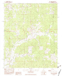
1983 Map of Pine Valley
USGS Topo · Published 1983About this map
The Pine Valley settlement serves as the focal point of this rural North Mississippi landscape, situated along the undulating drainage divide where the Yalobusha and Calhoun county line runs. The area is defined by a dense network of small waterways including Turkey Creek, Hurricane Creek, and Saunders Creek, which carve through the timbered terrain. This 1980s-era topographic survey captures a community deeply rooted in its local institutions, evidenced by the numerous country churches such as Tabernacle Ch, Hopewell Ch, and Bethel Ch that anchor the scattered homesteads.
Find a feature on this map
22 named features on this map. Tap any name to fly to it.
Don’t see what you’re looking for? This feature index may not catch every label — zoom into the map to look around manually.
Map Details
Editions of this 1983 Pine Valley Map
This is the sole edition of this map. No revisions or reprints were ever made.
Other maps of this area

1953 · West Point
USGS Topo · 1:250,000

1954 · Pittsboro
USGS Topo · 1:62,500

1954 · Water Valley
USGS Topo · 1:62,500

1954 · Water Valley West
USGS Topo · 1:24,000

1955 · Water Valley
USGS Topo · 1:62,500

1955 · Coffeeville
USGS Topo · 1:62,500

1956 · Tupelo
USGS Topo · 1:250,000

1958 · Tupelo
USGS Topo · 1:250,000

1958 · West Point
USGS Topo · 1:250,000

1963 · West Point
USGS Topo · 1:250,000