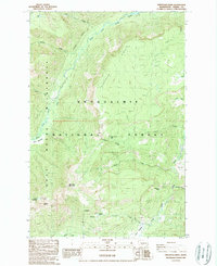
1988 Map of Pinegrass Ridge
USGS Topo · Published 1989About this map
Pinegrass Ridge dominates the high-country landscape of the Cascades in this late-1980s provisional survey of Yakima County. This area represents a protected intersection of alpine hydrology and forest management, where the Goat Rocks Wilderness meets the broader Snoqualmie National Forest. The network of drainages is remarkably dense, anchored by the North Fork Tieton River and feeding prominent water bodies such as Hell Lake, Clear Lake, and the sequestered Phantom Lake.
Find a feature on this map
29 named features on this map. Tap any name to fly to it.
Don’t see what you’re looking for? This feature index may not catch every label — zoom into the map to look around manually.
Map Details
Editions of this 1988 Pinegrass Ridge Map
This is the sole edition of this map. No revisions or reprints were ever made.
Other maps of this area

1902 · Mount Aix
USGS Topo · 1:125,000

1904 · Mt Aix
USGS Topo · 1:125,000

1904 · Mount Adams
USGS Topo · 1:125,000

1907 · Mount Adams
USGS Topo · 1:125,000

1950 · Yakima
USGS Topo · 1:250,000

1958 · Yakima
USGS Topo · 1:250,000

1961 · Yakima
USGS Topo · 1:250,000

1962 · White Pass
USGS Topo · 1:62,500

1967 · Rimrock Lake
USGS Topo · 1:24,000

1967 · Darland Mtn
USGS Topo · 1:24,000