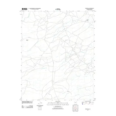
2011 Map of Piney Hill
USGS Topo · Published 2011About this map
Piney Hill and the surrounding high country of the Defiance Plateau dominate this high-desert landscape in Apache County. The terrain is defined by an intricate network of drainage systems, where Kinlichee Creek and Bonito Creek carve through the plateau. A system of tribal routes, including Indian Rte 2010 and Indian Rte 203, provides access to several named water sources such as Bonito Spring and Cold Spring. The presence of Talhchoze Tohe Meadow suggests the traditional importance of grazing or seasonal gathering areas within this territory. The hydrography of the region is further detailed through numerous named washes, including Black Soil Wash and Scattered Willow Wash, which trace the seasonal flow of water across the plateau toward the larger creek beds.
Find a feature on this map
22 named features on this map. Tap any name to fly to it.
Don’t see what you’re looking for? This feature index may not catch every label — zoom into the map to look around manually.
Map Details
Editions of this 2011 Piney Hill Map
This is the sole edition of this map. No revisions or reprints were ever made.
Other maps of this area

1886 · Fort Defiance
USGS Topo · 1:250,000

1892 · Fort Defiance
USGS Topo · 1:250,000

1954 · Gallup
USGS Topo · 1:250,000

1955 · Zith-Tusayan Butte 2 SE
USGS Topo · 1:24,000

1955 · Zith-Tusayan Butte 4 NW
USGS Topo · 1:24,000

1955 · Zith-Tusayan Butte 3 NE
USGS Topo · 1:24,000

1955 · Zith-Tusayan Butte 4 NE
USGS Topo · 1:24,000

1955 · Zith-Tusayan Butte 2 NE
USGS Topo · 1:24,000

1955 · Zith-Tusayan Butte 1 SE
USGS Topo · 1:24,000
1955 · Zith-Tusayan Butte 1 NE
USGS Topo · 1:24,000