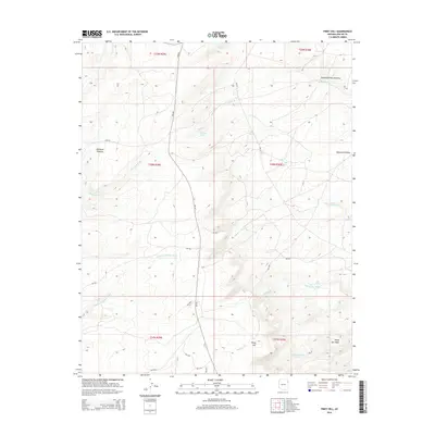
2014 Map of Piney Hill
USGS Topo · Published 2014About this map
The high elevation terrain of the Defiance Plateau dominates this landscape, where a network of ephemeral washes and perennial springs defines the local hydrology. Important water sources such as Beehbito Spring and Bonito Spring are mapped alongside significant drainages like Kinlichee Cr and Bonito Cr. The map reveals a remote area primarily navigated via Bureau of Indian Affairs routes, including Bia-201 and Bia-204, which connect the high ground of Piney Hill to the surrounding basins.
Find a feature on this map
29 named features on this map. Tap any name to fly to it.
Don’t see what you’re looking for? This feature index may not catch every label — zoom into the map to look around manually.
Map Details
Editions of this 2014 Piney Hill Map
This is the sole edition of this map. No revisions or reprints were ever made.
Other maps of this area

1886 · Fort Defiance
USGS Topo · 1:250,000

1892 · Fort Defiance
USGS Topo · 1:250,000

1954 · Gallup
USGS Topo · 1:250,000

1955 · Zith-Tusayan Butte 2 SE
USGS Topo · 1:24,000

1955 · Zith-Tusayan Butte 4 NW
USGS Topo · 1:24,000

1955 · Zith-Tusayan Butte 3 NE
USGS Topo · 1:24,000

1955 · Zith-Tusayan Butte 4 NE
USGS Topo · 1:24,000

1955 · Zith-Tusayan Butte 2 NE
USGS Topo · 1:24,000

1955 · Zith-Tusayan Butte 1 SE
USGS Topo · 1:24,000
1955 · Zith-Tusayan Butte 1 NE
USGS Topo · 1:24,000