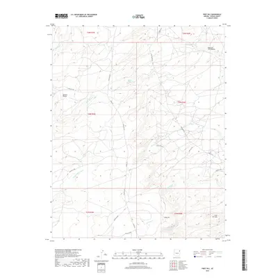
2018 Map of Piney Hill
USGS Topo · Published 2018About this map
Beehibito Spring and Bonito Spring offer vital water sources across this high-desert landscape on the Defiance Plateau. The terrain is defined by a series of drainage washes and creeks, including Kinlichee Cr and the descriptively named Black Soil Wash. In the northern reaches, the open expanse of Takhchoze Tohe-Meadow provides a break from the undulating topography. This 2018 survey documents a remote portion of Apache County, where the infrastructure is largely composed of unpaved routes such as Blue Canyon Rd and various Bureau of Indian Affairs roads like Indian Rte 73. The map is particularly useful for identifying named geographical landmarks such as Piney Hill and Cold Spring within the Fort Defiance Agency region.
Find a feature on this map
31 named features on this map. Tap any name to fly to it.
Don’t see what you’re looking for? This feature index may not catch every label — zoom into the map to look around manually.
Map Details
Editions of this 2018 Piney Hill Map
This is the sole edition of this map. No revisions or reprints were ever made.
Other maps of this area

1886 · Fort Defiance
USGS Topo · 1:250,000

1892 · Fort Defiance
USGS Topo · 1:250,000

1954 · Gallup
USGS Topo · 1:250,000

1955 · Zith-Tusayan Butte 2 SE
USGS Topo · 1:24,000

1955 · Zith-Tusayan Butte 4 NW
USGS Topo · 1:24,000

1955 · Zith-Tusayan Butte 3 NE
USGS Topo · 1:24,000

1955 · Zith-Tusayan Butte 4 NE
USGS Topo · 1:24,000

1955 · Zith-Tusayan Butte 2 NE
USGS Topo · 1:24,000

1955 · Zith-Tusayan Butte 1 SE
USGS Topo · 1:24,000
1955 · Zith-Tusayan Butte 1 NE
USGS Topo · 1:24,000