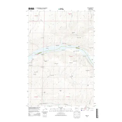
2014 Map of Ping
USGS Topo · Published 2014About this map
The Snake River carves a deep valley through the high plateau country of Garfield and Whitman Counties, creating a landscape defined by dramatic elevation changes and historical river-access points. Lake Bryan, the reservoir formed behind Little Goose Dam, dominates the center of the quadrangle, submerging much of the original riverbank where features like Penawawa Bar and Rice Bar are still identified. The settlement of Penawawa sits on the northern bank within Penawawa Canyon, while the namesake locality of Ping is situated to the south, tucked between the numerous steep drainages that feed into the main river system. This area is characterized by an extensive network of named gulches and ridges, such as Penawawa Ridge and Long Hollow Ridge, which represent the challenging topography early residents navigated. Modern routes like Wa-127 and local access roads such as Hastings Mill RD and Bratcher Grade RD follow these natural contours, connecting the isolated upland plateaus to the waterway below.
Find a feature on this map
50 named features on this map. Tap any name to fly to it.
Don’t see what you’re looking for? This feature index may not catch every label — zoom into the map to look around manually.
Map Details
Editions of this 2014 Ping Map
This is the sole edition of this map. No revisions or reprints were ever made.
Other maps of this area

1950 · La Crosse
USGS Topo · 1:62,500

1950 · Penawawa
USGS Topo · 1:62,500

1950 · Endicott
USGS Topo · 1:62,500

1950 · Hay
USGS Topo · 1:62,500

1952 · Hay
USGS Topo · 1:62,500

1952 · La Crosse
USGS Topo · 1:62,500

1955 · Pullman
USGS Topo · 1:250,000

1958 · Pullman
USGS Topo · 1:250,000

1981 · Dusty
USGS Topo · 1:24,000
1981 · Central Ferry
USGS Topo · 1:24,000