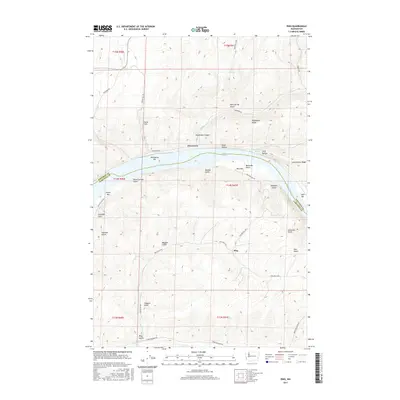
2017 Map of Ping
USGS Topo · Published 2017About this map
Penawawa and Ping occupy a landscape defined by the deep incision of the Snake River through the plateau. In this 2017 survey, the river is shown as Lake Bryan, a reservoir that has altered the original shoreline while leaving historical river features like Penawawa Bar, Rice Bar, and Swift Bar as prominent landmarks. The map illustrates the steep, technical road engineering required for the region, most notably seen at Fincher Grade and Bratcher Grade Rd, which descend from the high wheat-growing ridges down into the canyon floor.
Find a feature on this map
45 named features on this map. Tap any name to fly to it.
Don’t see what you’re looking for? This feature index may not catch every label — zoom into the map to look around manually.
Map Details
Editions of this 2017 Ping Map
This is the sole edition of this map. No revisions or reprints were ever made.
Other maps of this area

1950 · La Crosse
USGS Topo · 1:62,500

1950 · Penawawa
USGS Topo · 1:62,500

1950 · Endicott
USGS Topo · 1:62,500

1950 · Hay
USGS Topo · 1:62,500

1952 · Hay
USGS Topo · 1:62,500

1952 · La Crosse
USGS Topo · 1:62,500

1955 · Pullman
USGS Topo · 1:250,000

1958 · Pullman
USGS Topo · 1:250,000

1981 · Dusty
USGS Topo · 1:24,000
1981 · Central Ferry
USGS Topo · 1:24,000