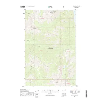
2020 Map of Pinnacle Mountain
USGS Topo · Published 2020About this map
Lake Chelan National Recreation Area and the Wenatchee National Forest dominate this high-elevation wilderness in the North Cascades. The terrain is defined by steep glacial valleys and prominent peaks such as Lucerne Mtn, Tinpan Mtn, and the namesake Pinnacle Mountain. Water systems are central to the landscape, with the headwaters of the Entiat River emerging from Entiat Meadows in the south, while the northern slopes drain toward the massive Lake Chelan. This 2020 survey illustrates the complex hydrography of the region, including the remote Dole Lakes and the dramatic Monkey Bear Falls along Railroad Creek. The inclusion of the Lower Railroad Creek Wilderness highlights a protected corridor essential for subalpine ecology. Local landmarks like Riddle Peaks and Flora Mtn provide fixed points for navigating the dense network of drainages including Ninemile Creek and Sevenmile Creek.
Find a feature on this map
42 named features on this map. Tap any name to fly to it.
Don’t see what you’re looking for? This feature index may not catch every label — zoom into the map to look around manually.
Map Details
Editions of this 2020 Pinnacle Mountain Map
This is the sole edition of this map. No revisions or reprints were ever made.
Other maps of this area

1902 · Stehekin
USGS Topo · 1:125,000

1904 · Stehekin
USGS Topo · 1:125,000

1944 · Holden
USGS Topo · 1:62,500

1944 · Lucerne
USGS Topo · 1:62,500

1949 · Lucerne
USGS Topo · 1:62,500

1949 · Holden
USGS Topo · 1:62,500

1955 · Concrete
USGS Topo · 1:250,000

1958 · Concrete
USGS Topo · 1:250,000

1962 · Concrete
USGS Topo · 1:250,000
1963 · Mt Lyall
USGS Topo · 1:24,000