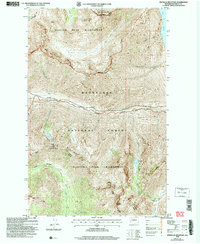
2004 Map of Pinnacle Mountain
USGS Topo · Published 2008About this map
Lake Chelan anchors the northeastern corner of this high-elevation mountain terrain within the Wenatchee National Forest. The landscape is dominated by the Chelan Mountains and the sharp relief of the Glacier Peak Wilderness. Two primary water systems carve through the topography: Railroad Creek flows eastward toward the lake, while the Entiat River drains the southwestern slopes. The map traces significant peaks such as Lucerne Mountain and Pinnacle Mountain, illustrating the steep drainages of Wolverine Creek and Lighting Creek. The transition between the Lake Chelan National Recreation Area and the surrounding forest reflects the complex administrative management of this wilderness at the start of the 21st century. High-altitude meadows and basins, including the Fourth of July Basin and Emerald Park, highlight the subalpine character of the region.
Find a feature on this map
28 named features on this map. Tap any name to fly to it.
Don’t see what you’re looking for? This feature index may not catch every label — zoom into the map to look around manually.
Map Details
Editions of this 2004 Pinnacle Mountain Map
This is the sole edition of this map. No revisions or reprints were ever made.
Other maps of this area

1902 · Stehekin
USGS Topo · 1:125,000

1904 · Stehekin
USGS Topo · 1:125,000

1944 · Holden
USGS Topo · 1:62,500

1944 · Lucerne
USGS Topo · 1:62,500

1949 · Lucerne
USGS Topo · 1:62,500

1949 · Holden
USGS Topo · 1:62,500

1955 · Concrete
USGS Topo · 1:250,000

1958 · Concrete
USGS Topo · 1:250,000

1962 · Concrete
USGS Topo · 1:250,000
1963 · Mt Lyall
USGS Topo · 1:24,000