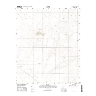
2017 Map of Pino Mountain
USGS Topo · Published 2017About this map
Pino Mountain stands as the central topographic feature in this arid stretch of Torrance County, rising above a landscape defined by ranch roads and historical markers. The map details a remote section of New Mexico where movement is dictated by a grid of routes such as Negra Rd and Pardo Rd, alongside the evocatively named Rawhide trail. For researchers of local genealogy, the presence of Pinos Wells Cem in the east and Cedarvale Cem to the south provides critical links to the families who established themselves in the township ranges of t3n r12e and t2n r12e. The sparse placement of these features reflects the expansive nature of the high desert environment and the cattle-driven economy that has long shaped the region's development and infrastructure.
Find a feature on this map
11 named features on this map. Tap any name to fly to it.
Don’t see what you’re looking for? This feature index may not catch every label — zoom into the map to look around manually.
Map Details
Editions of this 2017 Pino Mountain Map
This is the sole edition of this map. No revisions or reprints were ever made.
Other maps of this area

1954 · Fort Sumner
USGS Topo · 1:250,000

1958 · Fort Sumner
USGS Topo · 1:250,000

1978 · Negra SW
USGS Topo · 1:24,000

1978 · Negra SE
USGS Topo · 1:24,000

1978 · Rattlesnake Hill
USGS Topo · 1:24,000

1980 · Corona
USGS Topo · 1:100,000

1981 · Progresso NE
USGS Topo · 1:24,000

1981 · Pino Mountain
USGS Topo · 1:24,000
1981 · Progresso SE
USGS Topo · 1:24,000
1981 · Cedarvale NE
USGS Topo · 1:24,000