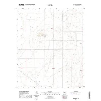
2020 Map of Pino Mountain
USGS Topo · Published 2020About this map
Pino Mtn dominates the high desert landscape of central Torrance County, rising above a network of isolated rural roads that define the region's ranching and transit history. This 2020 survey documents a vast, open terrain organized by section lines and historical land divisions. Local history and genealogy researchers will find the locations of Pinos Wells Cem in the eastern portion of the quadrangle and Cedarvale Cem along the southern border near Co Rd C009. These small burial grounds serve as quiet markers of the families who settled this arid corner of New Mexico. The map details the simple road network connecting these points, including Negra Rd, Pardo Rd, and the evocative Rawhide trail, reflecting the enduring character of the High Plains.
Find a feature on this map
13 named features on this map. Tap any name to fly to it.
Don’t see what you’re looking for? This feature index may not catch every label — zoom into the map to look around manually.
Map Details
Editions of this 2020 Pino Mountain Map
This is the sole edition of this map. No revisions or reprints were ever made.
Other maps of this area

1954 · Fort Sumner
USGS Topo · 1:250,000

1958 · Fort Sumner
USGS Topo · 1:250,000

1978 · Negra SW
USGS Topo · 1:24,000

1978 · Negra SE
USGS Topo · 1:24,000

1978 · Rattlesnake Hill
USGS Topo · 1:24,000

1980 · Corona
USGS Topo · 1:100,000

1981 · Progresso NE
USGS Topo · 1:24,000

1981 · Pino Mountain
USGS Topo · 1:24,000
1981 · Progresso SE
USGS Topo · 1:24,000
1981 · Cedarvale NE
USGS Topo · 1:24,000