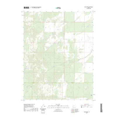
2023 Map of Pinto Spring
USGS Topo · Published 2023About this map
The high ridges of the Indian Peak Range dominate this interior landscape, marking a remote boundary between Beaver and Iron counties. This modern topographic survey highlights a network of vital water sources in an otherwise arid high-elevation environment, including a concentration of named springs such as Big Pinto Spring, Pinto Spring, and Merrill Camp Spring. The drainage patterns are clearly defined by Cottonwood Creek and Pinto Creek, which carve through the slopes alongside smaller seasonal flows like Atchison Creek and Sheep Creek. Historically significant for ranching and resource management, the map traces the subtle transitions in the landscape near Jackson Wash, providing a precise record of the topography and naming conventions used by the U.S. Geological Survey and other land management agencies.
Find a feature on this map
17 named features on this map. Tap any name to fly to it.
Don’t see what you’re looking for? This feature index may not catch every label — zoom into the map to look around manually.
Map Details
Editions of this 2023 Pinto Spring Map
This is the sole edition of this map. No revisions or reprints were ever made.
Other maps of this area

1953 · Richfield
USGS Topo · 1:250,000

1958 · Richfield
USGS Topo · 1:250,000

1971 · Observation Knoll
USGS Topo · 1:24,000

1971 · Pine Grove Reservoir
USGS Topo · 1:24,000

1971 · Pinto Spring
USGS Topo · 1:24,000

1971 · Steamboat Mtn SW
USGS Topo · 1:24,000

1971 · Bible Spring
USGS Topo · 1:24,000

1971 · Atchison Creek
USGS Topo · 1:24,000

1971 · Steamboat Mtn
USGS Topo · 1:24,000
1972 · Buckhorn Spring
USGS Topo · 1:24,000