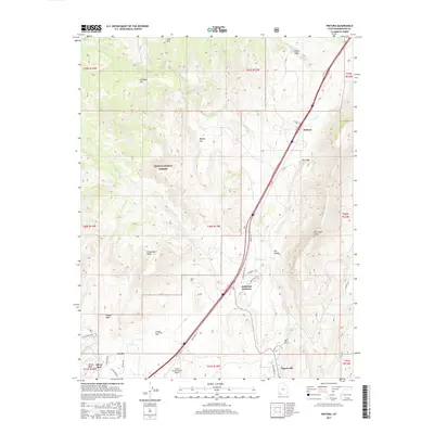
2017 Map of Pintura
USGS Topo · Published 2017About this map
The rugged geology of Washington County dominates this 2017 landscape, where the massive Hurricane Cliffs drop toward the drainage of Ash Creek. This corridor serves as a vital transportation artery, featuring the transition from Old US Hwy 91 to modern transit routes through Anderson Junction and the small settlement of Pintura. Notable for genealogists, the Pintura Cemetery sits near the northern end of this reach, while the southern portion reveals the residential expansion of Toquerville and Leeds. The map illustrates a landscape of stark contrasts, from the high elevations of the Dixie National Forest and Chimney Hill down to the arid stretches of Sandy Flat and Italian Wash. Aviation history is represented by the Crystal Springs Ranch Airport, while legacy mining interests are reflected in labels like White Reef and Silver Reef to the southwest.
Find a feature on this map
51 named features on this map. Tap any name to fly to it.
Don’t see what you’re looking for? This feature index may not catch every label — zoom into the map to look around manually.
Map Details
Editions of this 2017 Pintura Map
This is the sole edition of this map. No revisions or reprints were ever made.
Other maps of this area

1885 · St. George
USGS Topo · 1:250,000

1891 · St. George
USGS Topo · 1:250,000

1953 · Cedar City
USGS Topo · 1:250,000

1954 · La Verkin 4 NW
USGS Topo · 1:24,000

1954 · La Verkin 3 NW
USGS Topo · 1:24,000

1954 · La Verkin 3 NE
USGS Topo · 1:24,000

1954 · La Verkin 1 SW
USGS Topo · 1:24,000

1954 · La Verkin 2 SE
USGS Topo · 1:24,000

1954 · Hurricane
USGS Topo · 1:62,500

1957 · New Harmony
USGS Topo · 1:62,500