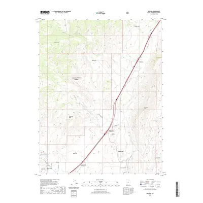
2020 Map of Pintura
USGS Topo · Published 2020About this map
Hurricane Cliffs dominate the eastern landscape of this Washington County survey, forming a dramatic geological backdrop for the settlements of Pintura and Anderson Junction. The map documents a corridor of transit and heritage, where Old US Hwy 91 and modern thoroughfares navigate the terrain between Dixie National Forest and the rising plateaus. Genealogists will find the Pintura Cem and Anderson Family Cem clearly marked, alongside the historical site of Silver Reef, a 19th-century mining town known for its unique silver-in-sandstone deposits. The hydrology of the region is well-defined by Ash Creek, Wet Sandy, and the Toquerville Springs, illustrating how water sources influenced early ranching and settlement patterns. Notable landmarks like the Crystal Springs Ranch Airport and the Silver Rim Trail reflect the modern utility of this varied landscape.
Find a feature on this map
42 named features on this map. Tap any name to fly to it.
Don’t see what you’re looking for? This feature index may not catch every label — zoom into the map to look around manually.
Map Details
Editions of this 2020 Pintura Map
This is the sole edition of this map. No revisions or reprints were ever made.
Other maps of this area

1885 · St. George
USGS Topo · 1:250,000

1891 · St. George
USGS Topo · 1:250,000

1953 · Cedar City
USGS Topo · 1:250,000

1954 · La Verkin 4 NW
USGS Topo · 1:24,000

1954 · La Verkin 3 NW
USGS Topo · 1:24,000

1954 · La Verkin 3 NE
USGS Topo · 1:24,000

1954 · La Verkin 1 SW
USGS Topo · 1:24,000

1954 · La Verkin 2 SE
USGS Topo · 1:24,000

1954 · Hurricane
USGS Topo · 1:62,500

1957 · New Harmony
USGS Topo · 1:62,500