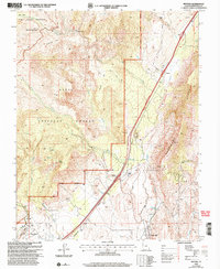
2002 Map of Pintura
USGS Topo · Published 2005About this map
The Hurricane Cliffs dominate the eastern landscape of this 2002 revision, where the dramatic elevation change separates the high plateau from the lower desert basins. Along the base of these cliffs, the settlement of Pintura and the Anderson Ranch sit near the critical corridor of Ash Creek. To the south, the community of Toquerville is positioned near the productive Toquerville Springs, illustrating the historical importance of water access in this arid environment.
Find a feature on this map
34 named features on this map. Tap any name to fly to it.
Don’t see what you’re looking for? This feature index may not catch every label — zoom into the map to look around manually.
Map Details
Editions of this 2002 Pintura Map
This is the sole edition of this map. No revisions or reprints were ever made.
Other maps of this area

1885 · St. George
USGS Topo · 1:250,000

1891 · St. George
USGS Topo · 1:250,000

1953 · Cedar City
USGS Topo · 1:250,000

1954 · La Verkin 4 NW
USGS Topo · 1:24,000

1954 · La Verkin 3 NW
USGS Topo · 1:24,000

1954 · La Verkin 3 NE
USGS Topo · 1:24,000

1954 · La Verkin 1 SW
USGS Topo · 1:24,000

1954 · La Verkin 2 SE
USGS Topo · 1:24,000

1954 · Hurricane
USGS Topo · 1:62,500

1957 · New Harmony
USGS Topo · 1:62,500