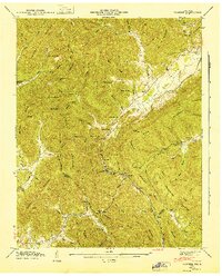
1946 Map of Pioneer
USGS Topo · Published 1947About this map
Pioneer stands as a focal point in the rugged coal and timber landscape of the Campbell County and Scott County border. This 1940s survey reveals a landscape shaped by resource extraction and steep topography, most notably marked by the Incline near Pioneer, which suggests the intense grades required for local industrial operations. The Southern railroad winds through the valleys, providing the primary artery for these remote mountain communities. Along the creeks and gaps, a network of rural education and faith is visible through sites like Terry Creek Sch and Rockhouse Sch, while the presence of an Oil Well near the Meredith Cem points to the diverse mineral interests of the era. The mapping of numerous family-named peaks such as Chimney Mountain and Braden Mountain underscores the deep-rooted local history and geography of these Cumberland Plateau ridges.
Find a feature on this map
129 named features on this map. Tap any name to fly to it.
Don’t see what you’re looking for? This feature index may not catch every label — zoom into the map to look around manually.
Map Details
Editions of this 1946 Pioneer Map
This is the sole edition of this map. No revisions or reprints were ever made.
Other maps of this area

1890 · Williamsburg
USGS Topo · 1:125,000

1893 · Briceville
USGS Topo · 1:125,000

1894 · Williamsburg
USGS Topo · 1:125,000

1895 · Briceville
USGS Topo · 1:125,000

1896 · Briceville
USGS Topo · 1:125,000

1936 · Ivydell
USGS Topo · 1:24,000

1936 · Block
USGS Topo · 1:24,000

1936 · Jacksboro
USGS Topo · 1:24,000

1936 · Pioneer
USGS Topo · 1:24,000

1936 · La Follette
USGS Topo · 1:48,000