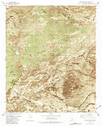
1982 Map of Pipeline Canyon
USGS Topo · Published 1982About this map
The Fort Bliss Military Reservation (Mc Gregor Range) dominates this high-desert landscape in Otero County during the early 1980s. This orthophotomap provides a rare hybrid view of the arid terrain, combining traditional topographic contouring with an underlying aerial photograph to reveal the distribution of scrub and exposed rock. Water management is the primary sign of human modification here, evidenced by the presence of Escondida Tank, Boone Tank, and a prominent Aqueduct that cuts across the northeastern reaches. The rugged path of Pipeline Canyon meanders through the central region, while scattered infrastructure like a isolated Corral and a Drill Hole point to livestock ranching and exploration occurring within or adjacent to the federal military boundary. This composite view illustrates the starkness of the New Mexico desert as it was utilized for both defense and resource management.
Find a feature on this map
20 named features on this map. Tap any name to fly to it.
Don’t see what you’re looking for? This feature index may not catch every label — zoom into the map to look around manually.
Map Details
Editions of this 1982 Pipeline Canyon Map
This is the sole edition of this map. No revisions or reprints were ever made.
Other maps of this area

1916 · Point Of Sands
USGS Topo · 1:125,000

1940 · Orogrande
USGS Topo · 1:62,500

1943 · Pendejo Wash
USGS Topo · 1:62,500

1943 · Orogrande
USGS Topo · 1:62,500

1947 · Orogrande North
USGS Topo · 1:24,000

1948 · Tres Hermanos
USGS Topo · 1:62,500

1950 · Escondido Canyon
USGS Topo · 1:62,500

1954 · Carlsbad
USGS Topo · 1:250,000
1955 · Orogrande North
USGS Topo · 1:24,000

1955 · Las Cruces
USGS Topo · 1:250,000