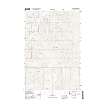
2014 Map of Piquett Creek
USGS Topo · Published 2014About this map
The Bitterroot National Forest dominates this section of Ravalli County, where the West Fork Bitterroot River carves a path through high-elevation terrain. This modern survey illustrates the remote infrastructure of the western edge of the forest, notably the West Fork Lodge Airport and a network of access points like Piquette Creek Rd and Kucera Rd N. Significant topographic landmarks define the horizon, from the heights of Rombo Mtn in the south to the prominent Rocky Knob in the east. Numerous drainage systems, such as Piquett Creek, Applebury Cr, and Beavertail Cr, create a complex hydrologic pattern. This map provides critical detail for navigating the transition from the river valley to the steep ridgelines near Buck Creek Saddle.
Find a feature on this map
37 named features on this map. Tap any name to fly to it.
Don’t see what you’re looking for? This feature index may not catch every label — zoom into the map to look around manually.
Map Details
Editions of this 2014 Piquett Creek Map
This is the sole edition of this map. No revisions or reprints were ever made.
Other maps of this area

1956 · Elk City
USGS Topo · 1:250,000

1960 · Elk City
USGS Topo · 1:250,000

1960 · Painted Rocks Lake
USGS Topo · 1:62,500

1960 · Piquett Mountain
USGS Topo · 1:62,500

1964 · Burnt Ridge
USGS Topo · 1:24,000

1964 · Boulder Peak
USGS Topo · 1:24,000
1964 · Trapper Peak
USGS Topo · 1:24,000
1964 · Robbins Gulch
USGS Topo · 1:24,000

1964 · Piquett Creek
USGS Topo · 1:24,000

1965 · Medicine Hot Springs
USGS Topo · 1:24,000