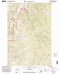
1998 Map of Piquett Creek
USGS Topo · Published 2002About this map
Bitterroot National Forest dominates this landscape in western Montana, where the Bitterroot River and the West Fork Bitterroot River converge. The terrain is defined by its dramatic drainage basins, as dozens of named waterways like Piquett Creek and Applebury Creek carve through the high country. Human activity is sparse and specialized, marked by the presence of a Landing Strip and a Gravel Pit tucked into the river valley. The map documents the administrative boundaries of the West Fork Sula Ranger District and follows the Base Line through the southern reaches of the quadrangle. Significant landmarks for navigation and land use include the Buck Creek Saddle and the summit of Romba Mountain, providing a clear record of this mountain environment as it was managed by the Forest Service and USGS in the late 1990s.
Find a feature on this map
32 named features on this map. Tap any name to fly to it.
Don’t see what you’re looking for? This feature index may not catch every label — zoom into the map to look around manually.
Map Details
Editions of this 1998 Piquett Creek Map
This is the sole edition of this map. No revisions or reprints were ever made.
Other maps of this area

1956 · Elk City
USGS Topo · 1:250,000

1960 · Elk City
USGS Topo · 1:250,000

1960 · Painted Rocks Lake
USGS Topo · 1:62,500

1960 · Piquett Mountain
USGS Topo · 1:62,500

1964 · Burnt Ridge
USGS Topo · 1:24,000

1964 · Boulder Peak
USGS Topo · 1:24,000
1964 · Trapper Peak
USGS Topo · 1:24,000
1964 · Robbins Gulch
USGS Topo · 1:24,000

1964 · Piquett Creek
USGS Topo · 1:24,000

1965 · Medicine Hot Springs
USGS Topo · 1:24,000