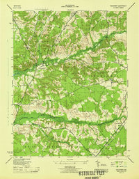
1944 Map of Piscataway
USGS Topo · Published 1944About this map
Hyde Field Army Air Base stands as a focal point in the north, reflecting the military's footprint in southern Maryland during the Second World War. This landscape at the border of Prince Georges and Charles Counties shows a rural transition where farming and forest meet expanding mid-century infrastructure. The village of Piscataway and the community at Waldorf are connected by a network of local roads such as McKendree Road and the Popes Creek Branch railroad. The map is particularly rich for genealogical research, documenting numerous rural meeting houses and centers of local life, including St Marys Church, Union Bethel Ch, and Ashbury Ch. From the tidal reaches of Piscataway Creek to the banks of Mattawoman Creek, the terrain is marked by family-named localities like Silesia, Tippett, and Berry, providing a clear record of 1940s settlement patterns before later suburban development.
Find a feature on this map
35 named features on this map. Tap any name to fly to it.
Don’t see what you’re looking for? This feature index may not catch every label — zoom into the map to look around manually.
Map Details
Editions of this 1944 Piscataway Map
This is the sole edition of this map. No revisions or reprints were ever made.
Other maps of this area

1890 · Mt. Vernon
USGS Topo · 1:125,000

1891 · Mt. Vernon
USGS Topo · 1:125,000

1892 · Brandywine
USGS Topo · 1:62,500

1894 · Mt. Vernon
USGS Topo · 1:125,000

1895 · Brandywine
USGS Topo · 1:62,500

1897 · Mt. Vernon
USGS Topo · 1:125,000

1899 · Patuxent
USGS Topo · 1:125,000

1900 · Washington
USGS Topo · 1:62,500

1906 · Patuxent
USGS Topo · 1:125,000

1911 · Brandywine
USGS Topo · 1:62,500