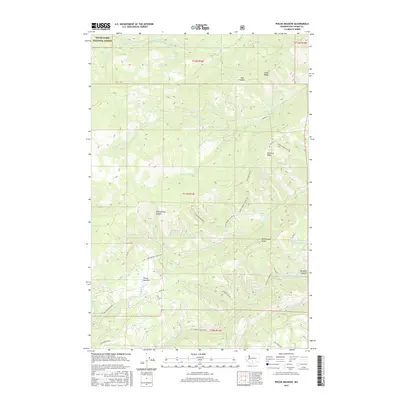
2017 Map of Piscoe Meadow
USGS Topo · Published 2017About this map
Piscoe Meadow and the surrounding highlands of Yakima County define this territory within the Snoqualmie National Forest. The landscape is a complex of significant ridges, including Sedge Ridge to the north and Ahtanum Ridge and Rattlesnake Ridge further south. This terrain is carved by a network of drainages such as Middle Fork Ahtanum Cr, Reservation Cr, and the N Fork Simcoe Cr.
Find a feature on this map
34 named features on this map. Tap any name to fly to it.
Don’t see what you’re looking for? This feature index may not catch every label — zoom into the map to look around manually.
Map Details
Editions of this 2017 Piscoe Meadow Map
This is the sole edition of this map. No revisions or reprints were ever made.
Other maps of this area

1899 · Ellensburg
USGS Topo · 1:125,000

1901 · Ellensburg
USGS Topo · 1:125,000

1902 · Mount Aix
USGS Topo · 1:125,000

1904 · Mt Aix
USGS Topo · 1:125,000

1904 · Mount Adams
USGS Topo · 1:125,000

1907 · Mount Adams
USGS Topo · 1:125,000

1937 · White Swan
USGS Topo · 1:125,000

1950 · Yakima
USGS Topo · 1:250,000

1957 · Yesmowit Canyon
USGS Topo · 1:24,000
1957 · Willy Dick Canyon
USGS Topo · 1:24,000