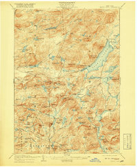
1908 Map of Piseco Lake
USGS Topo · Published 1918About this map
The waters of Piseco Lake dominate this survey of the southern Adirondack wilderness, where isolated 19th-century settlements like Piseco and Rudeston cling to the shoreline. The landscape is defined by the sharp verticality of Panther Mtn and Echo Cliff, rising abruptly above the lake. Away from the water, the map reveals a rugged interior of unnamed timberlands and family-named clearings such as Powley Place, Averys Place, and Shaker Place, suggesting a sparse network of logging camps and remote homesteads connected by early trails.
Find a feature on this map
114 named features on this map. Tap any name to fly to it.
Don’t see what you’re looking for? This feature index may not catch every label — zoom into the map to look around manually.
Map Details
Editions of this 1908 Piseco Lake Map
This is the sole edition of this map. No revisions or reprints were ever made.
Other maps of this area
1899 · Indian Lake
USGS Topo · 1:62,500
1900 · Little Falls
USGS Topo · 1:62,500
1900 · Canada Lake
USGS Topo · 1:62,500
1900 · Wilmurt
USGS Topo · 1:62,500
1901 · Old Forge
USGS Topo · 1:62,500
1901 · Lassellsville
USGS Topo · 1:62,500
1902 · Wilmurt
USGS Topo · 1:62,500
1902 · Indian Lake
USGS Topo · 1:62,500
1903 · West Canada Lakes
USGS Topo · 1:62,500
1903 · Gloversville
USGS Topo · 1:62,500