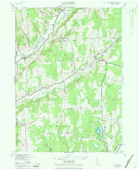
1943 Map of Pitcher
USGS Topo · Published 1984About this map
The Otselic River valley anchor this 1943 survey, revealing the rural character of Chenango County during the mid-century. This map, reprinted for civil use by the Corps of Engineers from a military edition, documents a network of highland farms and hamlets connected by dirt and gravel roads such as Shingle Road and Brakel Road. The landscape is dotted with early educational and religious foundations, including Brakel Ch and several numbered schoolhouses like School No 6 and School No 4.
Find a feature on this map
49 named features on this map. Tap any name to fly to it.
Don’t see what you’re looking for? This feature index may not catch every label — zoom into the map to look around manually.
Map Details
Editions of this 1943 Pitcher Map
2 editions found

Other maps of this area

1902 · Coventry
USGS Topo · 1:62,500

1903 · Norwich
USGS Topo · 1:62,500

1904 · Greene
USGS Topo · 1:62,500

1904 · Oxford
USGS Topo · 1:62,500

1904 · Pitcher
USGS Topo · 1:62,500

1943 · Otselic
USGS Topo · 1:24,000

1943 · South Ostelic
USGS Topo · 1:24,000

1943 · Cincinnatus
USGS Topo · 1:24,000

1943 · East Pharsalia
USGS Topo · 1:24,000

1943 · Cuyler
USGS Topo · 1:24,000