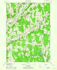
1944 Map of Pitcher
USGS Topo · Published 1964About this map
Otselic River valley dominates this 1940s landscape, winding through a region characterized by small rural hamlets and upland dairy country. The settlement of Pitcher and nearby North Pitcher are connected by a network of early roads like Randall Road and Grewe Road, while the higher elevations are marked by distinctive landmarks like Birdlebough Hill and Oak Hill. Numerous one-room schoolhouses, including School No 1 and School No 3, are still identified, reflecting a decentralized educational system typical of the era.
Find a feature on this map
46 named features on this map. Tap any name to fly to it.
Don’t see what you’re looking for? This feature index may not catch every label — zoom into the map to look around manually.
Map Details
Editions of this 1944 Pitcher Map
3 editions found
Other maps of this area

1902 · Coventry
USGS Topo · 1:62,500

1903 · Norwich
USGS Topo · 1:62,500

1904 · Greene
USGS Topo · 1:62,500

1904 · Oxford
USGS Topo · 1:62,500

1904 · Pitcher
USGS Topo · 1:62,500

1943 · Otselic
USGS Topo · 1:24,000

1943 · South Ostelic
USGS Topo · 1:24,000

1943 · Cincinnatus
USGS Topo · 1:24,000

1943 · East Pharsalia
USGS Topo · 1:24,000

1943 · Cuyler
USGS Topo · 1:24,000