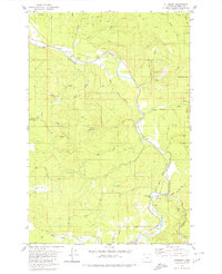
1979 Map of Pittsburg
USGS Topo · Published 1980About this map
Nehalem River meanders through this portion of Columbia County, defining the valley floor where the small settlements of Natal and Pittsburg are established. By the late 1970s, the landscape reflects a heavy reliance on timber and natural resource management, indicated by the extensive network of logging roads like Mainline and Burris Road that penetrate the surrounding uplands. A significant portion of the western terrain is dedicated to the Clatsop State For, while localized landmarks such as Big Eddy Park and a Forest Service Station near the river junction highlight the area's recreational and administrative functions. The presence of a Quarry and numerous small water bodies, including Hawkins Lake and Lindsay Lake, suggests a rugged environment shaped by both geological extraction and the drainage patterns of the Nehalem Valley. Local history is noted by a solitary Grave in the central hills, a quiet marker of early habitation amidst the dense forest.
Find a feature on this map
40 named features on this map. Tap any name to fly to it.
Don’t see what you’re looking for? This feature index may not catch every label — zoom into the map to look around manually.
Map Details
Editions of this 1979 Pittsburg Map
This is the sole edition of this map. No revisions or reprints were ever made.
Other maps of this area

1919 · Mayger
USGS Topo · 1:62,500

1940 · Vernonia
USGS Topo · 1:62,500

1941 · Keasey
USGS Topo · 1:62,500

1941 · Clatskanie
USGS Topo · 1:62,500

1941 · Cathlamet
USGS Topo · 1:62,500

1943 · Vernonia
USGS Topo · 1:62,500

1943 · Keasey
USGS Topo · 1:62,500

1948 · Vancouver
USGS Topo · 1:250,000

1950 · Vancouver
USGS Topo · 1:250,000

1950 · Vancouver
USGS Topo · 1:250,000