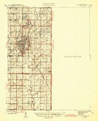
1945 Map of Pittsburg
USGS Topo · Published 1945About this map
Coal mining operations dominate the landscape surrounding Pittsburg during the mid-1940s, characterized by numerous Strip Mine sites that scar the terrain across the Kansas and Missouri border. This industrial footprint is interlaced with a dense network of rail lines, including the Missouri Pacific, ST Louis San Francisco, and Southern railroads, which served the region's heavy mineral extraction. Beyond the industrial core of Frontenac and Dunkirk, the map reveals a rural social infrastructure of one-room schools such as Gaskell Sch and Neutral Sch, alongside the developing Atkinson Municipal Airport. The southern portion transitions into the agricultural reaches of Pleasant View, where Cow Creek and Brush Creek wind through the township, providing a detailed record of the Crawford and Cherokee county borderlands before modern land reclamation transformed the old mining districts.
Find a feature on this map
42 named features on this map. Tap any name to fly to it.
Don’t see what you’re looking for? This feature index may not catch every label — zoom into the map to look around manually.
Map Details
Editions of this 1945 Pittsburg Map
2 editions found

Other maps of this area

1884 · Fort Scott
USGS Topo · 1:125,000

1886 · Nevada
USGS Topo · 1:125,000

1886 · Joplin
USGS Topo · 1:125,000

1886 · Fort Scott
USGS Topo · 1:125,000

1886 · Carthage
USGS Topo · 1:125,000

1893 · Fort Scott
USGS Topo · 1:125,000

1894 · Nevada
USGS Topo · 1:125,000

1894 · Joplin
USGS Topo · 1:125,000

1894 · Carthage
USGS Topo · 1:125,000

1918 · Columbus
USGS Topo · 1:62,500