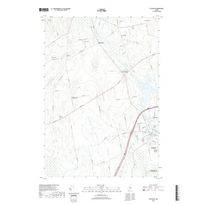
2018 Map of Pittsfield
USGS Topo · Published 2018About this map
The Sebasticook River winds through this central Maine landscape, connecting the rural hamlets of Thompson, West Palmyra, and Waverley with the larger hub of Pittsfield. The topography is defined by significant elevations such as Huff Hill, Ford Hill, and Negro Hill, while the lowlands are dominated by expansive wetlands like Canaan Bog. This 2018 survey reveals a landscape where modern transportation infrastructure, including the Pittsfield Municipal Airport and Interstate 95, intersects with historical footprints. Genealogists will find several burial grounds across the quadrangle, from Warren Hill Cem in the north to the West Pittsfield Cem further south. The drainage patterns of Thompson Brook, Meadow Brook, and Johonnett Brook illustrate the intricate water network feeding into Douglas Pond, reflecting the area's transition from traditional agricultural and timber lands to a more contemporary Maine community.
Find a feature on this map
74 named features on this map. Tap any name to fly to it.
Don’t see what you’re looking for? This feature index may not catch every label — zoom into the map to look around manually.
Map Details
Editions of this 2018 Pittsfield Map
This is the sole edition of this map. No revisions or reprints were ever made.
Other maps of this area

1892 · Waterville
USGS Topo · 1:62,500

1913 · Skowhegan
USGS Topo · 1:62,500

1926 · Burnham
USGS Topo · 1:62,500

1930 · Pittsfield
USGS Topo · 1:48,000

1932 · Pittsfield
USGS Topo · 1:62,500

1933 · Pittsfield
USGS Topo · 1:62,500

1943 · Waterville
USGS Topo · 1:62,500

1948 · Bangor
USGS Topo · 1:250,000

1955 · Pittsfield
USGS Topo · 1:62,500

1955 · Skowhegan
USGS Topo · 1:62,500