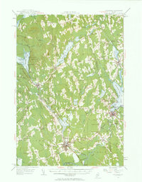
1955 Map of Pittsfield
USGS Topo · Published 1963About this map
Pittsfield and Newport anchor this mid-century portrait of Central Maine, where the Maine Central railroad and a network of brooks connect numerous family-named crossroads. The landscape is defined by the significant waters of Great Moose Lake and Sebasticook Lake, supporting recreation and early industry at sites like the Wild Goose Club and Big Indian Camps. The map details a transition from the agricultural heritage of Palmyra and Ripley toward the development of mid-century infrastructure, including a Substation, Drive-in Theater, and a private Airport near the Sebasticook River. Local genealogy is well-served by the many small burials and rural institutions, such as Pine Grove Cem and the Palmyra Consolidated Sch, which reflect the community structure of Somerset and Penobscot counties during this era.
Find a feature on this map
129 named features on this map. Tap any name to fly to it.
Don’t see what you’re looking for? This feature index may not catch every label — zoom into the map to look around manually.
Map Details
Editions of this 1955 Pittsfield Map
2 editions found

Other maps of this area

1892 · Waterville
USGS Topo · 1:62,500

1913 · Skowhegan
USGS Topo · 1:62,500

1926 · Burnham
USGS Topo · 1:62,500

1930 · Pittsfield
USGS Topo · 1:48,000

1931 · Stetson
USGS Topo · 1:48,000

1932 · Brooks
USGS Topo · 1:62,500

1932 · Dover-Foxcroft
USGS Topo · 1:48,000

1932 · Pittsfield
USGS Topo · 1:62,500

1933 · Pittsfield
USGS Topo · 1:62,500

1933 · Guilford
USGS Topo · 1:62,500