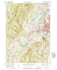
1973 Map of Pittsfield West
USGS Topo · Published 1977About this map
The western edges of Pittsfield and the rolling hills of the Berkshires meet in this detailed topographic record. The landscape is defined by its deep cultural history, most notably at Shaker Village and the surrounding heights of Shaker Mtn. To the north and south, the map documents the transition from the city’s industrial and residential core out toward the New York state line. Large bodies of water like Onota Lake and Richmond Pond anchor the local geography, surrounded by mid-century developments, youth camps like Camp Russell, and the Pontoosuc Lake Country Club.
Find a feature on this map
80 named features on this map. Tap any name to fly to it.
Don’t see what you’re looking for? This feature index may not catch every label — zoom into the map to look around manually.
Map Details
Editions of this 1973 Pittsfield West Map
4 editions found
Other maps of this area

1886 · Greylock
USGS Topo · 1:62,500

1886 · Becket
USGS Topo · 1:62,500

1888 · Becket
USGS Topo · 1:62,500

1888 · Berlin
USGS Topo · 1:62,500

1888 · Pittsfield
USGS Topo · 1:62,500

1890 · Pittsfield
USGS Topo · 1:62,500

1890 · Berlin
USGS Topo · 1:62,500

1891 · Greylock
USGS Topo · 1:62,500

1893 · Becket
USGS Topo · 1:62,500

1893 · Greylock
USGS Topo · 1:62,500