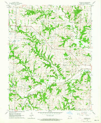
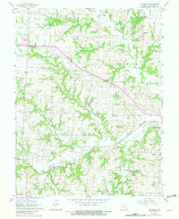
1963 Map of Pittsville
USGS Topo · Published 1964About this map
Pittsville and Columbus anchor this rural landscape in western Johnson County during the early 1960s. The area is defined by the convergence of the North Fork Blackwater River and the South Fork Blackwater River, which carve intricate drainage patterns across the terrain. Small community focal points are scattered throughout the countryside, including Blackwater Station Ch, St Johns Ch, and Rock Springs Bible Ch. These rural institutions, alongside the Haymaker Cem, serve as vital landmarks for those tracing mid-century family history or land ownership patterns in the townships of Jackson and Madison. The presence of a Quarry near Pin Oak Creek reflects the local resource extraction that supplemented the region's agricultural character, while the winding course of Little Blackwater Creek highlights the natural hydrology that shaped settlement boundaries.
Find a feature on this map
18 named features on this map. Tap any name to fly to it.
Don’t see what you’re looking for? This feature index may not catch every label — zoom into the map to look around manually.
Map Details
Editions of this 1963 Pittsville Map
2 editions found
Other maps of this area

1885 · Warrensburg
USGS Topo · 1:125,000

1887 · Harrisonville
USGS Topo · 1:125,000

1887 · Warrensburg
USGS Topo · 1:125,000

1892 · Harrisonville
USGS Topo · 1:125,000

1894 · Harrisonville
USGS Topo · 1:125,000

1894 · Warrensburg
USGS Topo · 1:125,000

1947 · Jefferson City
USGS Topo · 1:250,000

1947 · Lawrence
USGS Topo · 1:250,000

1950 · Lawrence
USGS Topo · 1:250,000

1954 · Jefferson City
USGS Topo · 1:250,000