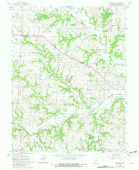
1963 Map of Pittsville
USGS Topo · Published 1981About this map
Pittsville and Columbus anchor this rural Johnson County landscape, where the headwaters of the Blackwater River system carve through the terrain. The map reveals a deeply rooted community structure defined by its townships, including Jackson, Columbus, Centerview, and Madison. Small-scale industry and local gathering points are evident through several Quarry sites and a network of country churches like St Johns Ch and Rock Springs Bible Ch.
Find a feature on this map
17 named features on this map. Tap any name to fly to it.
Don’t see what you’re looking for? This feature index may not catch every label — zoom into the map to look around manually.
Map Details
Editions of this 1963 Pittsville Map
2 editions found
Other maps of this area

1885 · Warrensburg
USGS Topo · 1:125,000

1887 · Harrisonville
USGS Topo · 1:125,000

1887 · Warrensburg
USGS Topo · 1:125,000

1892 · Harrisonville
USGS Topo · 1:125,000

1894 · Harrisonville
USGS Topo · 1:125,000

1894 · Warrensburg
USGS Topo · 1:125,000

1947 · Jefferson City
USGS Topo · 1:250,000

1947 · Lawrence
USGS Topo · 1:250,000

1950 · Lawrence
USGS Topo · 1:250,000

1954 · Jefferson City
USGS Topo · 1:250,000