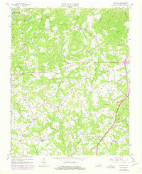
1964 Map of Pittsville
USGS Topo · Published 1978About this map
Pigg River flows into the northern reaches of Leesville Lake in this mid-1960s snapshot of Pittsylvania County, which was updated in the late 1970s to reflect localized developments like The Cedars Country Club. The landscape is a network of small upland settlements including Pittsville, Climax, and Whittles, the latter of which sits along the Southern railroad line. The map reveals a deeply rooted rural community defined by its proximity to water and religion, evidenced by numerous crossroads churches such as Burning Bush Ch, Siloam Ch, and Watson Level Ch. The presence of several family-named features like Walkers Well and Pullens indicates a region of long-standing lineage, while a solitary mine near the lake suggests a history of small-scale mineral extraction in the shadow of Farmers Mountain.
Find a feature on this map
42 named features on this map. Tap any name to fly to it.
Don’t see what you’re looking for? This feature index may not catch every label — zoom into the map to look around manually.
Map Details
Editions of this 1964 Pittsville Map
2 editions found
Other maps of this area

1890 · Roanoke
USGS Topo · 1:125,000

1891 · Roanoke
USGS Topo · 1:125,000

1892 · Lynchburg
USGS Topo · 1:125,000

1921 · Chatham
USGS Topo · 1:48,000

1922 · Callands
USGS Topo · 1:48,000

1923 · Chatham
USGS Topo · 1:62,500

1924 · Callands
USGS Topo · 1:62,500

1944 · Callands
USGS Topo · 1:62,500

1947 · Roanoke
USGS Topo · 1:250,000

1951 · Moneta
USGS Topo · 1:62,500