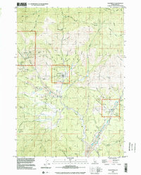
1998 Map of Placerville
USGS Topo · Published 2002About this map
Placerville and its surrounding mining districts remain the focus of this late-20th-century topographic record, which documents a landscape heavily shaped by generations of extraction. The settlement patterns reflect a legacy of prospecting, with clusters of activity near Centerville and New Centerville along the lower reaches of Grimes Creek. The terrain is deeply incised by named gulches such as Slaughterhouse Gulch and Illinois Gulch, many of which show evidence of historical surface work. Significant industrial traces appear throughout the quadrangle, notably the extensive Tailings deposits at Mud Flat and numerous specific operations like the Leary Placer Mine and Gold Hill Mine. For the local historian, the map preserves the exact locations of isolated landmarks like Brassey Ranch and the high point at Alder Creek Summit, alongside various Prospects that point to the region's enduring identity as a mineral-rich corridor within the Boise County highlands.
Find a feature on this map
67 named features on this map. Tap any name to fly to it.
Don’t see what you’re looking for? This feature index may not catch every label — zoom into the map to look around manually.
Map Details
Editions of this 1998 Placerville Map
This is the sole edition of this map. No revisions or reprints were ever made.
Other maps of this area

1892 · Boise
USGS Topo · 1:125,000

1894 · Squaw Creek
USGS Topo · 1:125,000

1894 · Idaho Basin
USGS Topo · 1:125,000

1897 · Boise
USGS Topo · 1:125,000

1909 · Garden Valley
USGS Topo · 1:125,000

1953 · Banks
USGS Topo · 1:62,500

1955 · Baker
USGS Topo · 1:250,000

1955 · Hailey
USGS Topo · 1:250,000

1955 · Boise
USGS Topo · 1:250,000

1957 · Placerville
USGS Topo · 1:24,000