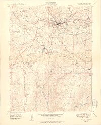
1950 Map of Placerville
USGS Topo · Published 1950About this map
Placerville and its surrounding Sierra Nevada foothills appear in this mid-century survey, revealing a landscape shaped by gold rush legacy and agricultural development. The map details a mix of active settlements and fading sites, notably Cold Springs (Site) and Logtown (Site). These former mining centers are set against a network of ridges and ravines, including Logtown Ridge and the deep cuts of Weber Creek.
Find a feature on this map
69 named features on this map. Tap any name to fly to it.
Don’t see what you’re looking for? This feature index may not catch every label — zoom into the map to look around manually.
Map Details
Editions of this 1950 Placerville Map
2 editions found
Other maps of this area

1891 · Placerville
USGS Topo · 1:125,000

1892 · Placerville
USGS Topo · 1:125,000

1893 · Placerville
USGS Topo · 1:125,000

1947 · Sacramento
USGS Topo · 1:250,000

1948 · Sacramento
USGS Topo · 1:250,000

1949 · Georgetown
USGS Topo · 1:62,500

1949 · Placerville
USGS Topo · 1:62,500

1949 · Placerville
USGS Topo · 1:24,000
1949 · Coloma
USGS Topo · 1:24,000
1949 · Latrobe
USGS Topo · 1:24,000