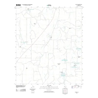
2010 Map of Placid
USGS Topo · Published 2010About this map
Placid serves as the central settlement in this landscape defined by a network of ranch roads and water management sites in McCulloch County. The area’s geography is shaped by the presence of numerous small-scale reservoirs and dams, such as the Soil Conservation Service Site 1 Lake and the Deep Creek Watershed Reservoir Number Four, which reflect a concerted effort to manage local hydrology for agriculture. Prominent elevations including Round Mountain, Packsaddle Hill, and the Corn Creek Hills punctuate the terrain, providing clear landmarks across the ranchlands. These physical features, alongside named sites like Curtis Ranch Field, offer a detailed perspective on the region's land use during the early 21st century. The map also documents the infrastructure of the era through a dense grid of county roads, including Co RD 460 and Co RD 430, which connect the scattered rural homesteads and livestock tanks.
Find a feature on this map
30 named features on this map. Tap any name to fly to it.
Don’t see what you’re looking for? This feature index may not catch every label — zoom into the map to look around manually.
Map Details
Editions of this 2010 Placid Map
This is the sole edition of this map. No revisions or reprints were ever made.
Other maps of this area

1894 · Brady
USGS Topo · 1:125,000

1924 · Brady 2-a
USGS Topo · 1:48,000

1925 · Brady 1-b
USGS Topo · 1:48,000

1925 · Brady 1-a
USGS Topo · 1:48,000

1928 · Mercury
USGS Topo · 1:62,500

1928 · Waldrip
USGS Topo · 1:62,500

1950 · Mercury
USGS Topo · 1:62,500

1954 · Brownwood
USGS Topo · 1:250,000

1960 · Brady North
USGS Topo · 1:24,000
1963 · Lost Creek
USGS Topo · 1:24,000