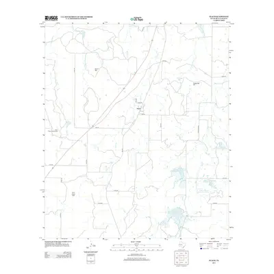
2013 Map of Placid
USGS Topo · Published 2013About this map
The small settlement of Placid serves as the focal point of this McCulloch County survey, situated at the junction of local ranch roads in a landscape defined by water management and ranching. The geography is marked by a sophisticated network of water control features, including the Soil Conservation Service-Site 1 Lake and several numbered reservoirs along Deep Cr. These man-made improvements reflect a mid-to-late 20th-century emphasis on flood control and livestock watering in the Texas Hill Country.
Find a feature on this map
37 named features on this map. Tap any name to fly to it.
Don’t see what you’re looking for? This feature index may not catch every label — zoom into the map to look around manually.
Map Details
Editions of this 2013 Placid Map
This is the sole edition of this map. No revisions or reprints were ever made.
Other maps of this area

1894 · Brady
USGS Topo · 1:125,000

1924 · Brady 2-a
USGS Topo · 1:48,000

1925 · Brady 1-b
USGS Topo · 1:48,000

1925 · Brady 1-a
USGS Topo · 1:48,000

1928 · Mercury
USGS Topo · 1:62,500

1928 · Waldrip
USGS Topo · 1:62,500

1950 · Mercury
USGS Topo · 1:62,500

1954 · Brownwood
USGS Topo · 1:250,000

1960 · Brady North
USGS Topo · 1:24,000
1963 · Lost Creek
USGS Topo · 1:24,000