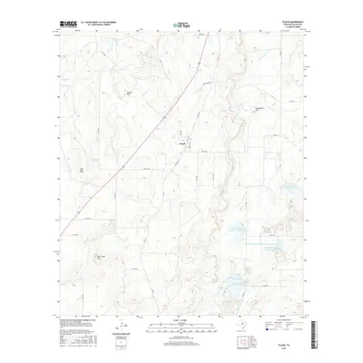
2016 Map of Placid
USGS Topo · Published 2016About this map
The small settlement of Placid sits at the center of this rural McCulloch County landscape, where the drainage basins of Cedar Cr and Deep Cr meet. This modern survey reflects a region defined by water management and ranching operations, with numerous man-made features such as Herberg Lake and the Deep Cr Watershed Reservoir Number Four scattered across the undulating terrain. Local topography is marked by distinctive elevations including Round Mtn, Packsaddle Hill, and the Corn Creek Hills, providing natural landmarks for the surrounding ranchlands.
Find a feature on this map
39 named features on this map. Tap any name to fly to it.
Don’t see what you’re looking for? This feature index may not catch every label — zoom into the map to look around manually.
Map Details
Editions of this 2016 Placid Map
This is the sole edition of this map. No revisions or reprints were ever made.
Other maps of this area

1894 · Brady
USGS Topo · 1:125,000

1924 · Brady 2-a
USGS Topo · 1:48,000

1925 · Brady 1-b
USGS Topo · 1:48,000

1925 · Brady 1-a
USGS Topo · 1:48,000

1928 · Mercury
USGS Topo · 1:62,500

1928 · Waldrip
USGS Topo · 1:62,500

1950 · Mercury
USGS Topo · 1:62,500

1954 · Brownwood
USGS Topo · 1:250,000

1960 · Brady North
USGS Topo · 1:24,000
1963 · Lost Creek
USGS Topo · 1:24,000