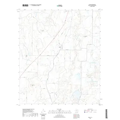
2019 Map of Placid
USGS Topo · Published 2019About this map
Placid serves as the central hub of this McCulloch County landscape, situated at the junction of FM 1028 and FM 2315. The terrain is defined by its watershed management and ranching legacy, featuring prominent elevations like Round Mtn and Packsaddle Hill that rise above the surrounding plains. Water resources are carefully managed through a series of reservoirs, including Deep Cr Watershed Reservoir Number Two and Deep Cr Watershed Reservoir Number Four, alongside smaller private stock tanks such as Cedar Cr-Tank and Z Ranch Lake. The network of county roads, such as Co RD 460 and Co RD 464, reveals the property divisions and access routes essential to the local cattle and agricultural operations. A prominent southwest-to-northeast corridor is formed by Highway 377, cutting a straight line across the drainage patterns of Corn Cr and the Corn Creek Hills.
Find a feature on this map
38 named features on this map. Tap any name to fly to it.
Don’t see what you’re looking for? This feature index may not catch every label — zoom into the map to look around manually.
Map Details
Editions of this 2019 Placid Map
This is the sole edition of this map. No revisions or reprints were ever made.
Other maps of this area

1894 · Brady
USGS Topo · 1:125,000

1924 · Brady 2-a
USGS Topo · 1:48,000

1925 · Brady 1-b
USGS Topo · 1:48,000

1925 · Brady 1-a
USGS Topo · 1:48,000

1928 · Mercury
USGS Topo · 1:62,500

1928 · Waldrip
USGS Topo · 1:62,500

1950 · Mercury
USGS Topo · 1:62,500

1954 · Brownwood
USGS Topo · 1:250,000

1960 · Brady North
USGS Topo · 1:24,000
1963 · Lost Creek
USGS Topo · 1:24,000