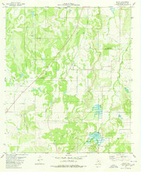
1979 Map of Placid
USGS Topo · Published 1980About this map
Placid serves as the central settlement on this late-1970s landscape in McCulloch County, where the terrain is defined by a network of seasonal water sources and distinct geological elevations. The rural economy is visible through the presence of several stock tanks such as Cedar Creek Tank, Clay Hole Tank, and Georges Tank, which support ranching in an area where water management is vital. Significant topographic landmarks rise above the creek beds, including Round Mountain and Packsaddle Hill, while the Corn Creek Hills dominate the southwestern portion of the quadrangle.
Find a feature on this map
20 named features on this map. Tap any name to fly to it.
Don’t see what you’re looking for? This feature index may not catch every label — zoom into the map to look around manually.
Map Details
Editions of this 1979 Placid Map
This is the sole edition of this map. No revisions or reprints were ever made.
Other maps of this area

1894 · Brady
USGS Topo · 1:125,000

1924 · Brady 2-a
USGS Topo · 1:48,000

1925 · Brady 1-b
USGS Topo · 1:48,000

1925 · Brady 1-a
USGS Topo · 1:48,000

1928 · Mercury
USGS Topo · 1:62,500

1928 · Waldrip
USGS Topo · 1:62,500

1950 · Mercury
USGS Topo · 1:62,500

1954 · Brownwood
USGS Topo · 1:250,000

1960 · Brady North
USGS Topo · 1:24,000
1963 · Lost Creek
USGS Topo · 1:24,000