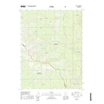
2019 Map of Placita
USGS Topo · Published 2019About this map
Coal Basin and its industrial legacy define the northern reaches of this Pitkin County landscape, where the Coal Basin Spur and Mine No. 4 intersect with the steep terrain of the White River National Forest. The geography is dominated by dramatic elevation changes, notably along Huntsman Ridge and the prominent Huntsman Mtn. To the south, the settlement of Placita sits along the Crystal River, a corridor marked by the Placita River Road and proximity to Hayes Creek Falls. The map details a transition from resource extraction in the high country to the river-valley connections at McClure Pass. High-altitude features like Island Lake and the open grounds of Dexter Park are mapped alongside numerous drainages such as Bear Cr and Dutch Cr, illustrating the complex hydrology that feeds the valley below.
Find a feature on this map
41 named features on this map. Tap any name to fly to it.
Don’t see what you’re looking for? This feature index may not catch every label — zoom into the map to look around manually.
Map Details
Editions of this 2019 Placita Map
This is the sole edition of this map. No revisions or reprints were ever made.
Other maps of this area

1957 · Leadville
USGS Topo · 1:250,000

1959 · Leadville
USGS Topo · 1:250,000

1960 · Leadville
USGS Topo · 1:250,000

1960 · Marble
USGS Topo · 1:24,000

1960 · Redstone
USGS Topo · 1:24,000

1961 · Mount Sopris
USGS Topo · 1:24,000

1962 · Leadville
USGS Topo · 1:250,000
1963 · Chair Mountain
USGS Topo · 1:24,000
1963 · Bull Mountain
USGS Topo · 1:24,000
1963 · Placita
USGS Topo · 1:24,000